While no trip to San Francisco is complete without a stroll across the Golden Gate Bridge, visitors in many cases are often surprised to learn that the Golden Gate Bridge isn’t the only game in town for spectacular bridge crossings with million-dollar views. So, say hello to the Bay Bridge Trail that lets pedestrians and bikers cross a portion of San Francisco’s “other” bridge.
The Bay Bridge Trail is a 4.4-mile pedestrian and bike path that stretches from the East Bay city of Emeryville and across the Bay Bridge’s eastern span before touching down on Yerba Buena Island. The 2.2-mile stretch that traverses the bridge offers unbelievable views that rival those of the Golden Gate Bridge.
Whether you’re into urban adventures or just taking in spectacular views from unlikely spots, the Bay Bridge Trail is worth the legwork it takes to get there. Suitable for all skill levels, those who make the effort to try it are treated to an exciting Bay Area experience that the tour books have yet to get wind of. So lace up the sensible shoes or dust off that bike, we’re off to experience the Bay Bridge Trail!
About the Bay Bridge Trail
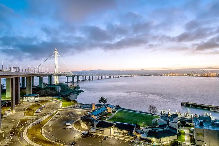
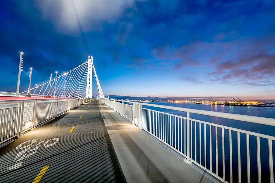
The trail is actually two interconnected segments dedicated to bicycles and pedestrians. The first section is an overland path from Emeryville to an Oakland touchdown that opened in September 2013. The second section is a slightly uphill stretch that crosses the eastern span of Bay Bridge. Opened in October 2016, this section rolls from Oakland to a landing area on Yerba Buena Island, giving cyclists and pedestrians amazing views of the span’s impressive 525-foot tower and modern design. The 15.5-foot-wide path runs along the southern side of the bridge. It has a lane in each direction for cyclists and an outside lane specifically for pedestrians.
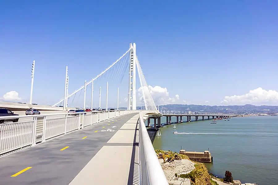
The path features seven observation platforms that offer jaw-dropping views of San Francisco and Oakland, the Bay’s vast expanse, and the surrounding landscape. In fact, the panoramic city views from the Bay Bridge are arguably even more impressive than those of the Golden Gate Bridge. The city seems so close you can almost touch it, and the beauty of the Bay is truly astonishing, especially at dusk. Watching massive shipping trawlers pass underneath the bridge on their way to and from the Port of Oakland is always an amazing sight.
Those concerned about the close proximity of cars whooshing by need not worry. A unique venting system keeps exhaust away from the path, while the span’s modern design configurations keep traffic noise at a level that’s easy on the ears. Still, it’s best to bring earplugs along, especially if crossing the path at peak traffic times. There’s no shade anywhere along the trail, so sunscreen and hats are recommended, although those hats may be buffeted by winds that can be strong and gusty at times.
The trail is stroller-and-wheelchair friendly, and while dogs on leashes are allowed, skateboards, scooters, and skates are not. The trail is patrolled by bike-riding California Highway Patrol (CHP) officers, whose responsibility is to keep the trail safe and ensure that bike traffic moves along within the 15 MPH speed limit. The Bay Bridge Trail is open seven days a week, 24 hours a day from Emeryville’s trailhead to Burma Road in Oakland. The eastern span bike and pedestrian path are open from 6:00 AM to 9:00 PM. Best of all, traversing the Bay Bridge Trail is free.
How To Access the Bay Bridge Trail
There are three access points that provide a direct route to the bicycle and pedestrian path: near the IKEA store at 4400 Shellmound Street in Emeryville; from the Caltrans Bridge Yard Building at 210 Burma Road in Oakland; and Vista Point on Yerba Buena Island, where the path and bridge make their landing. Click here for detailed information on how to access these three points.
To get to the trail from San Francisco, take the 25 Muni bus from the Salesforce Transit Center at 425 Mission Street to 9th Street and Avenue H on Yerba Buena Island. Head westbound to the shuttle stop at 9th Street and Avenue of the Palms, and then take the Treasure Island Shuttle to the Bay Bridge Vista Point. Bikers will be happy to learn that all Muni buses come equipped with a front bike rack.
Visitors based in San Francisco should note that the Bay Bridge Trail cannot be directly accessed from the San Francisco side; you’ll need to get to Yerba Buena Island first. Unfortunately, there is no pedestrian/bike path on the Bay Bridge’s western span at this time.
Bay Area Answers Fun Fact: The Bay Bridge Trail, also known as the Alex Zuckermann Path, is named after Bay Area bicycle legend Alex Zuckermann, who championed the creation of the eastern span bike path. Mr. Zuckermann founded the East Bay Bicycle Coalition in 1972 and was instrumental in expanding bicycle ridership throughout the Bay Area, including persuading BART to allow bikes aboard their trains. Mr. Zuckermann died in 2007, at the age of 86. A plaque honoring his legacy can be found on the trail path.
Other Posts of Interest
- How Long Does It Take to Walk Across the Golden Gate Bridge?
- Are There Sharks in San Francisco Bay?
- How Many Bridges Are in the San Francisco Bay Area?
- How Do You Get Around on Angel Island?
Parking and Facilities
Limited five-hour parking is available at the Bay Bridge Trail parking lot at the Burma Road Caltrans Bridge Yard Building. To get there from Burma Road, follow the signs that read “Bay Bridge Trail Parking Lot” for approximately a half-mile. Take a right where directed and continue to follow the signs to the parking lot entrance.
There’s no parking near the landing on Yerba Buena Island, but there is a weekend bicycle shuttle from Treasure Island to the Yerba Buena Island landing of the Bay Bridge. Click here for shuttle information. Restrooms and trash receptacles are available along the trail before reaching the bridge, but there are no restrooms on the bridge portion of the trail. Restroom facilities and drinking water are available at Yerba Buena Island Vista Point.
Exploring Yerba Buena and Treasure Islands
Whether you start or end your Bay Bridge Trail adventure on Yerba Buena Island, leave some time to explore the island and its neighbor, Treasure Island. While both offer fun outdoor activities off the familiar tourist paths, visitors might wonder what’s the difference, if any, between the two?
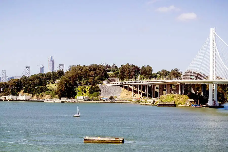
The key difference is Yerba Buena Island is a natural land formation while Treasure Island is manmade. Yerba Buena is hilly and Treasure Island is flat. The two have an overall area of 0.9 square miles, are connected by a small isthmus, and both are within the city and county of San Francisco.
Yerba Buena Island is known for its natural beauty, vibrant eco-system, and stunning views of San Francisco and the Bay Bridge. Those who hike or ride around the island will find themselves communing with nature in a peaceful place that’s far from the crush of tourists. A lighthouse built in 1874 and that’s still in use today is a fun destination, and secluded Clipper Cove Beach is popular for picnics, fishing, paddle boarding, and dog walking.
Treasure Island was created by the federal government using fill materials dredged from the Bay. Built in 1936 to host the 1939-1940 Golden Gate International Exposition, it was taken over by the United States Navy in 1942, serving as Naval Station Treasure Island until 1997. At that time, it was decommissioned and opened to the public. Treasure Island is now home to approximately 3,064 permanent residents, enough for it to be considered “San Francisco’s newest neighborhood.”
To drive to the islands from San Francisco or the East Bay, follow Interstate 80 onto the Bay Bridge and take the “Treasure Island/Yerba Buena Island” exit midway across the bridge. After exiting the highway, you can drive straight into Treasure Island along Treasure Island Road. Free parking is abundant, but a toll is required for drivers heading to the islands from the East Bay.
About the San Francisco-Oakland Bay Bridge
The San Francisco-Oakland Bay Bridge was completed in 1936 after three years of construction, establishing a permanent crossing between the cities of San Francisco and Oakland. Upon completion, the 8-mile long bridge was the world’s longest and most expensive to build. The western span anchorage alone was taller than any building in San Francisco or Oakland at the time. It currently carries approximately 247,720 vehicles daily, making it the most heavily traveled bridge in the Bay Area and the third busiest bridge in the country.
Wrapping It Up
Depending on your pace or how many times you stop to take in the views, walking the Bay Bridge Trail can take 2 hours, less if you’re riding a bike. Fold in time to explore Yerba Buena/Treasure Island, and you can spend the good portion of a day enjoying this unique sightseeing experience. While getting there from San Francisco takes some planning, this authentic “only in the Bay Area” experience makes the effort well worth it.